Saturday, June 29, 2019

Alaskabike--Back to Anchorage


Saturday, June 29, 2019
It’s now the morning after the last day of the tour, and as I write
this I’m sitting at the front of the top deck of the M.V. Aurora of the Alaska Marine Highway.  We’ll soon be departing on the five hour trip to Whittier where we’ll get onto another Alaskabike van back to Anchorage.   The van that has gone with us all week is being driven back to Anchorage with all of our luggage plus the bikes and other supplies and will get there in about the same amount of time as it will take us.  Probably saves Alaskabike a lot of money compared to taking the van and trailer on the ferry.  It is likely that the owner of Alaskabike, Walt Rowland, will be driving the van that will meet us at the ferry.

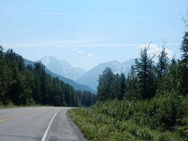
The final day was probably the most scenic day of cycling.  We departed Glenallen in the van and were driven down the Richardson Highway about 20 miles to begin our 55 mile ride.  It was a day of mountains, streams, some waterfalls, and rushing waters.  Some of the waters are crystal clear, but others are either
gray or brown depending upon the minerals in the soil that the stream or river passes through.  Since most of the streams are fed by melting snow in the mountains, the water is extremely cold as one member of our group confirmed when he stuck his head into one of the streams.

The morning was essentially downhill, but not to a notable degree.  However, as I rode and chatted with other riders it made the morning go by pretty quickly.  One thing that was very noticeable today was that as we got closer to Valdez, the traffic on the Richardson Highway increased.  Of course by East Coast standards it was still pretty light traffic, with there often being a minute or two between vehicles passing (as opposed to three or four minutes
when we were further north on the highway).

About 40 miles into the ride, there was a major road repair project going on as the road swung upwards toward an eventual crossing of Thompson Pass.  The section of single lane traffic was much too long for them to allow the bicycles to ride through, so after our final lunch on the road the bicycles were reloaded on top of the van and we were driven for a couple of miles through the work zone.  Then we re-boarded the bicycles for the climb up to Thompson Pass. The four mile climb covered 650 feet of elevation gain, or 163 feet per mile!  That’s about four to five times as steep as most rides around D.C.


At the top of Thompson Pass there was a dirt trail that went about 400 yards up to the top of a ridge which overlooked the Keystone Canyon were we were headed.  The road down to the Canyon headed down in the opposite direction for about a mile, then went through a 180 degree turn and continued its descent.  For almost ten miles it was unnecessary to pedal, with speeds down the hill in excess of 30 mph for those who didn’t ride their brakes. 

Finally at the bottom of the steep descent the road came up along the Lowe River.  This river ran swiftly with gray colored water.  It turned into a narrow canyon where we saw several kayakers braving the rushing waters.  Several of us sped up trying to get ahead of them to get their picture.  I was barely able to and then turned my attention to Bridal Falls which plummets several hundred feet down to the river below.  Less than a quarter of a mile, after going around a turn to the right between the canyon walls we came to a pullout area at Horsetail Falls.  We all pulled in there, marveled at the plunging water, took a group photo, and the bicycling portion of our trip came to an end.


In total, I rode 378 miles (would have had 400 miles if I had not needed to take a leg out of the trip on day 3) in 30 hours and 5 minutes. That's an average of 12.6 mph.  I now have 2,226.25 miles this year.

On balance it was a very good tour.  The biggest disappointment was that most of the people did not get the chance to see a moose, with the exception of two people on the third day who saw one of the big fellows come out on the road and almost get hit by a car.  But the moose safely ran off and most of us never got the chance to see it.  The closest I got was the chance to pose with the moose statue in front of the lodge in Glenallen.

What made this tour so good was that instead of doing the normal “tourist route” of riding a bus up the Parks Highway to Denali, staying at a modern motel, and being herded in groups, we got to see the “real” Alaska.  A couple of nights we stayed in cabins and comfortable lodges.  We did not eat in hotels.  We ate in local restaurants that Walt and Greg Rowland have discovered in their years of taking cyclists and multisport tourists around the state.  And by being on the bicycles we got to hear the sounds of nature in Alaska—rushing waters, birds, and at times the most pleasing sound of all.  Silence.

Since we headed off on this trip just two days after the summer solstice, we also experienced the “midnight sun.”  Technically the sun did set sometime after midnight, but it never got dark outside.  In the evening, we’d eat and there was no feeling of a need to get done with dinner to get back to go to sleep, because even at 10:30 p.m. it was still sunny out.  I can only imagine the problem that parents in Alaska have getting their kids to go to bed in the summer.  Of course the flip side comes in the winter when places to the north like Fairbanks have only a few house of sunlight!

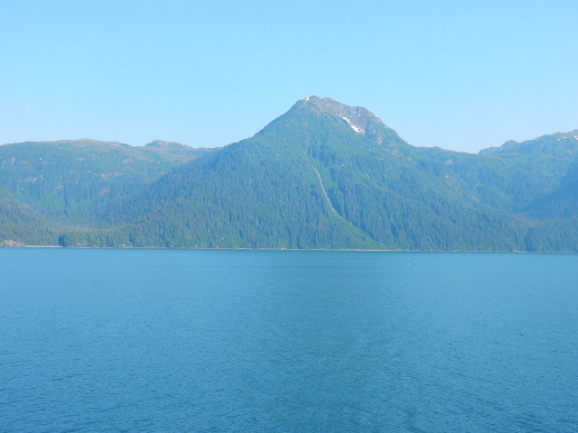
We left Valdez about 45 minutes ago and are slowly making our way out toward the Prince William Sound for the trip across to Whittier.  It’s easy to see why this short trip takes about five hours.  We seem to be moving at the speed of a hybrid bicycle!  As we sail down through the Valdez Arm toward the Sound, there are still some traces of snow visible near the peaks of the cliffs, but now the predominant color has become green.

Although this tour was disappointing in regard to moose sightings, near the midway point we were treated to a whale sighting off in the distance on the right, and soon after we enjoyed some even closer action as a couple of porpoises paced the boat, breaking to the surface several times, no more than about 25 feet off the right side.

As I have mentioned earlier in this blog, with the trip to Alaska I’ve now been in all 50 states.  The states in which I’ve cycled now total 32, but it’s time to turn my attention to making all of the arrangements for two more trips this summer—one to Connecticut, Rhode Island and Maine in either late July or early August, and a late August trip on which I hope to bring the cycled states total to 43, with the addition of Tennessee, Mississippi, Louisiana, Missouri, Illinois, Indiana and Michigan.  Included on this trip will be ballgames in Atlanta and Detroit, leaving only four ballparks and seven cycling states to plan for in 2020.
Tomorrow it’s off to Seward, Alaska on the Alaska Railroad train and the Kenai Fjords National Park cruise, before returning to Anchorage and flying back to Washington on Monday.

Although there will be no cycling involved, I will post some pictures of tomorrow's trip and then give everybody a break for awhile until I firm up plans for states 33-35!

Bruce

Friday, June 28, 2019

Alaskabike Day 6--The Final Day

Friday, June 28, 2019

Today was the final day of the tour.  It was a great day with terrific mountain views, passing the Worthington Glacier, going over Thompson Pass, a long fast descent and final miles along the Lowe River, through Keystone Canyon to our final stop at Horsetail Falls.  We then drove into Valdez for our final night before boarding the ferry to Anchorage.

Due to the late hour, and the early hour of the ferry sailing, this will be all that I can post tonight.  I'll list the two parts of today's ride.  The first part was to a section of the road that was under construction where we had to ride in the van, and then the second part going up over Thompson Pass.

Here's that data, and a few pictures below.  Check back on Saturday evening or Sunday morning for the full report from today.

Thanks for following along on this blog.  I now have 32 states cycled in, with 18 to go.  It's been a good, challenging tour and I'll provide more details and photos tomorrow.

Bruce

Part 1
https://connect.garmin.com/modern/activity/3793837048
Part 2
https://connect.garmin.com/modern/activity/3793837104

 
This is as close as I got to a moose!


Great scenery today.

More great scenery

Leslie, her son and I.

The Chugatch Mountains

My bike for the last week

Worthington Glacier

The road up to Thompson Pass

At Thompson Pass after climbing 650 feet in four miles

Keystone Canyon

Rafting on the Lowe River

Our happy tour group at Horsetail Falls at the end of the ride. 
Greg, the tour leader, is in front. 
I'm the third from the left in my new Alaskabike jersey.


Thursday, June 27, 2019

Alaskabike Day 5--Denali Highway to Gakona


Thursday, June 27, 2019


It’s the next to last cycling day of our trip.  We left our overnight stay at the Tangle River Inn, drove seven miles east on the Denali Highway to our starting point (which started with over four miles of fast downhill).  We continued east to Paxson (which was our ending point yesterday), then turned south on the Richardson Highway.  A left turn on the “Tok Cut Off” brought us to the Gakona Lodge, a roadhouse that has been in business since 1904.  The day represented nearly 72 miles, except for the two riders who decided to rack up the seven “bonus miles” between the Tangle River Inn and the rest of the group’s starting location, and yours truly who got a flat about two miles from the Gakona Lodge destination.


But this post will not focus too much on the ride, but rather give some overview of what the past five days have meant.  Alaskabike, a local company in Anchorage that is essentially a family run company, shows its riders the “real” Alaska.  Except in Fairbanks, where we stayed in the hotel built by Holland America Lines for its passengers who have come north to see some of Alaska, our overnight stays have been mainly at small lodges or cabins.  We’ve eaten in very good local restaurants that Bill and Greg Rowland who run the company, have discovered in their years of living in Alaska and running Alaskabike.


Unlike some of the larger companies who operate bike tours in Alaska,  Alaskabike keeps its tours small (no more than 13 people), and includes everything (I have not opened my wallet since arriving in Anchorage five nights ago, except for some cold medicine.  And to find that cold medicine, Greg Rowland drove me to a local IGA market in Delta Junction willingly).


Typically breakfast is at 8:00 a.m. either at the place we’re staying or we’ll drive to a nearby restaurant.  We then start out either on our bikes, or in the van to the starting place for the ride.  We normally will be on the bikes sometime around 9:30 a.m.  One of the two Alaskabike guides rides in the van to set up water and snack stops or lunch stops, and the other guide bikes somewhere behind the rearmost rider so that there is always someone to take care of problems that might arise (such as my flat tire).


Some days we’ve had great scenery that looks like what you would expect on an Alaska postcard.  Today, after some of that Alaska scenery we spent the afternoon riding on the two-lane Richardson Highway that could have been a rural road anywhere in the Eastern United States.  But this was really one of the few times on the trip where the scenery has not left me “oohing and ahhhing.”


Unfortunately, no moose sightings all week.  We’ve got one more chance tomorrow on our 53 mile ride to Valdez.  Speaking of wildlife sightings, another interesting thing is the lack of animal “roadkill” on the two highways we’ve ridden.  And there’s also something of a lack of cars.  It’s not unusual to go five minutes or more with no vehicles passing by.  And when one comes by, it’s more likely than a car to be a pickup truck, mobile home, tanker truck, or a car pulling a boat, camper or other outdoor activity item.  Alaska is clearly an outdoors state.


Tomorrow I’ll have the details of the final day of riding.  Here is the data from today’s ride, followed by a few pictures.  


Bruce


Today’s data:


The morning view from the Denali Highway
What's left of the abandoned town of Paxson

Tracey gets a water and snack stop set up.

Lot's of isolated dwelling around the state.

The "Tok Cut Off", the road to Gakona Lodge

Or if you keep going you'll reach the Canadian border.

The view of the Chitina River where my day ended thanks to a flat!


Alaskabike Day 4--Heading "Off the Grid"


Wednesday, June 26, 2019
As I mentioned in yesterday’s post, tonight we are at the Tangle River Inn on the Denali Highway which runs between the Richardson Highway and the Parks Highway, and is “off the grid.”  So this is being written on Wednesday night but will not get posted until Thursday. Everybody in the group said that today’s ride, 67 miles from south of Delta Junction to Paxson, AK was probably the best day of the tour so far.

I continued to fight a cold which made the ride tougher than it would otherwise have been.  And it didn’t start off too well.  After our 20 mile van ride to our starting point, my bike was taken off the roof of the van and it had a flat front tire.  Greg of Alaskabike checked the tire for glass or some other intrusion but found nothing. So I got a new tube and off I went.  Fortunately the problem did not repeat itself.   I felt good as I started out, but at about mile 5 the road turned sharply upward.  During the four mile climb it became necessary to make a couple of stops to take  some cold medicine that I had picked up the night before or blow my nose.  Twice, Tracy who was the Alaskabike sweeper on her bike following the rearmost rider (that was me) stopped to find out if I was ok.

I pressed on, and at the top of the grade reached the first SAG stop which was at a section of the Alaska Pipeline (see the picture below).  Greg suggested that I ought to complete the next 18 mile segment, and if I didn’t feel better ride the van for the third segment.
 
By the time I reached that second rest stop I knew I had to try to keep going.  The views were already spectacular.  Snow capped mountains, innumerable clear streams running to the Delta River that we were following, various overlooks into valleys below, Rainbow Mountain, the hope that maybe today would be the day to see a moose (no such luck ensued!), Summit Lake, and finally a six mile descent to our end point in Paxson.

Although I struggled at times, by the afternoon I felt a bit better (still making plenty of stops to use the tissues and to sneeze which became prevalent in the afternoon).  The black flies, gnats and mosquitos began to show up more than they had in the last several days.  But I pressed on, as did everyone else, including Leslie who was battling a cold like I was (I hope she didn’t catch it from me!).  We all ended up pretty close together at Paxson.  A van ride on the Denali Highway took us to the Tangle River Inn.

Thursday we’ll start on the little traveled Denali Highway about seven miles east of our overnight stop. We’ll cover 13 miles back to Paxson and then head south again on the Richardson Highway toward our next to last overnight of the tour in Glenallen. Greg assures us all that tomorrow will be even better than today!

As an aside, I’m still trying to get used to the midnight sun.  It’s 10:15 p.m. as I finish this post. The sky is still light. I don’t know how people who live here get their kids to go to bed at a reasonable time!
Below is the link to today’s data for the 67 miles, followed by pictures from the ride.
Bruce


Our first view of the pipeline about ten miles south of where we started.

Me at the pipeline.  Notice that I did pay attention to the sign
and did not climb on the pipeline!

A downhill is a cyclist's best friend.

Haze from fires in northern Alaska,
but snow covered mountain tops can still be made out.

Part of our group at a lunch stop:  Bindu, her husband Jason, me, Tracey with Alaskabike,
and in the front row is "Oxman" from Thailand.

A little bit clearer snow capped mountains


Grey mud in the Delta River caused  by the sediments in the soil. 

Lunch stop next to the Delta River.  Leslie, her son Alex, and Bill (L-R)

Rainbow Mountain next to the Delta River

A short distance south of Rainbow Mountain
the Delta River runs very quickly through a tight turn.

The marker poles which stretch over the road on each side keep
the snow plows following the right course when plowing after a heavy storm.

Summit Lake outside Paxson.

This sign is as close as we've gotten to a moose!